Due to the high attenuation of electromagnetic waves in water, acoustic waves have become the main medium for underwater communication and localization.
A Sonar (sound navigation and ranging) works like a radar, but since its wavelength is much smaller than that of radar, the sonar effect is more like a B – mode ultrasound scan. Some popular Sonars are introduced as below:
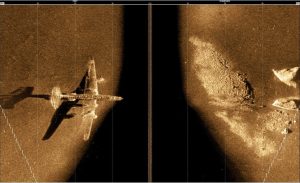
I. Side-Scan Sonar
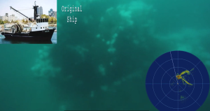
It is mainly used for seabed terrain scanning and underwater target searching. Its effect is shown in the following image. The side-scan sonar consists of two arrays on the left and right. The acoustic shadow area in the middle is also a representative feature of the side-scan sonar. If the target is in this area, it cannot be detected. Therefore, when using the side-scan sonar, the target sea area to be searched is generally divided into several blocks and scanned one by one. Each block is scanned horizontally and vertically respectively.
Product recommendation: Side Scan Sonar 454OEM
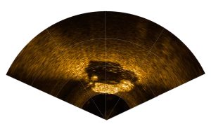
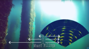
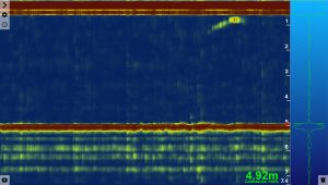
II. Imaging Sonar
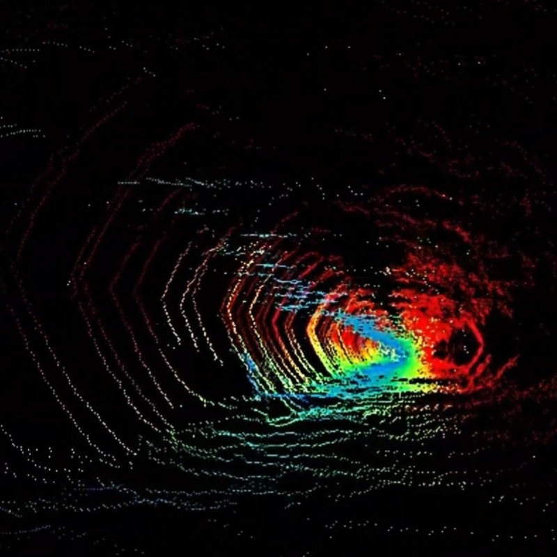
The imaging sonar, also known as the multi-beam imaging sonar, is generally used for underwater target searching. It can search for targets from the water surface, and can also be mounted on a ROV to search for targets up close from underwater. The imaging sonar is an important tool for searching for targets in turbid water. The underwater scanning effect is shown in the following figure. The multi-beam sonar generally presents a fan-shaped diagram, and the ruler provided by the software can be used to measure the size of the target, which is convenient for confirming the target. The advantage of the dual-frequency multi-beam sonar is that it has two central frequencies. One can achieve the search for distant targets at around 100 meters, while the other high frequency can be used for close-range detailed observation. It can be used for observation even in turbid waters.
Product recommendation: M750d
III. Underwater Positioning
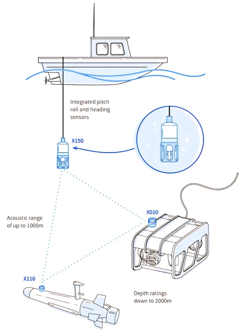
Underwater positioning is also known as underwater GPS. Since there is no underwater GPS signal, in fact, underwater positioning is a combination of GPS and underwater acoustics for positioning. The operational schematic diagram is shown below. The geodetic coordinates of the mother ship are determined through GPS positioning, and at the same time, the coordinates of the hull of the underwater ROV are determined through the acoustic transceiver. The geodetic coordinates of the underwater ROV are calculated through coordinate transformation.
Underwater localization can obtain the real-time position of the underwater ROV, the effect are shown as below.
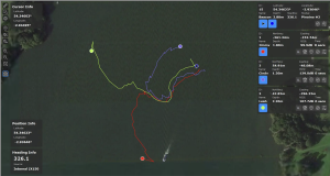
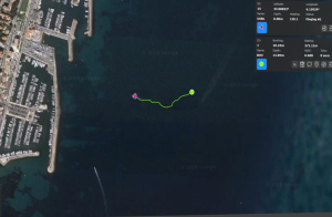
USBL Underwater Positioning
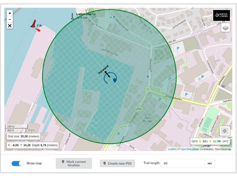
SBL Underwater Ppsitioning (UGPS)
That said, Underwater Positioning systems are not recommended for shallow waters within 30m depth where the ROV can be easily located and neither USBL or SBL does not present good results. However, in deep waters, USBL & SBL improves working efficiency greatly, especially during the 2nd dive of ROV, AUV or divers.
Product Recommendation: USBL Underwater Positioning System, SBL Underwater Positioning System
IV. Pipe Profiling Sonar
Pipe Sonars, also called profiling sonars, presents accurate cross-section profiles of internal pipes. Choose the sonar based on the inner diameter of your pipe, you can use profiling sonars alone or mounted on ROVs.

3D modelinng of internal pipes is also available with pipe profiling data.
Product Recommendation: Mini Pipe Sonar 2512E, Pipe Sonar 1512E
V. Obstacle Avoidance Sonar
Obstacle Avoidance Sonar, also called mechanical scanning sonar. It does not gives the 360° contour at one time, but scans sector by sector. The scanning range can be set to 360° or partial sectors.
Recommend Products: Ping 360 Scanning Sonar, MICRON Mechanical Sonar
VI.Underwater Altimeter
The altimeter operates based on the principle of echo sounding, enabling the mapping ROV/AUV/USV to measure the heights above the seabed or the distance to surrounding obstacles. Typical effective range goes up to 100 meters, though its performance may be affected by soft seabeds. It can be used for surveying riverbeds, under bridge piers, offshore wind turbine foundations, docks, and other underwater structures. It is also suitable for sediment mapping in reservoirs, rivers, and water tanks, as well as for marine scientific research and water quality monitoring where precise altitude control is required. Additionally, it can serve as an obstacle avoidance sensor for ROV/AUV navigation.
Recommed Product: Underwater Altimeter Echo Sounder